The Island
“… a name once commonly used for a certain Clackamas County Area”
Clackamas County Historical Society, 1964-1965
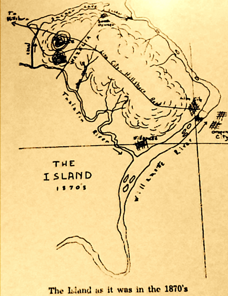
Can you name the waterways that make the “Island” possible?
“I have not heard it for many years. The area became an island of sorts in 1871 when the Canal between the Tualatin River and the head of Sucker (Oswego) Lake cut it off on the west. The lake and its outlet, Sucker Creek, on the north, the Willamette River on the east and the Tualatin River on the south complete the water circuit. South Oswego, West Linn and Willamette are its towns.”
Harriet D. Munnick, 1800s
“The Island” was a name once commonly used for a certain Clackamas County Area. The waterways that help create the “Island” are fed by numerous creeks and streams that are vital watersheds that help support our regional active agriculture and wildlife habitat. There are thirteen stream corridors that flow through the region.
We have used portions of the 2018 Metro Urban Growth Report to help identify the numerous creeks and streams in the region of which “Locals” probably have names for some of the smaller ones. Here are the 13 creeks and streams that help make up the “Island” and provide water for the active agriculture in our region:
- The first stream, which is unnamed, flows along the western edge of the reserve area for 1,370 feet through five rural residential properties. The stream includes a wooded riparian canopy with slopes greater than 25%, and there is riparian and some upland habitat identified along the stream corridor, starting above Childs road and flowing south.
- Pecan Creek flows west of SW Stafford Road and SW Pattulo Way for 1.2 miles. Over 3,000 feet of the creek flows through land either owned by Metro (open space), City of Lake Oswego (park) or Portland General Electric. The remaining portion of the stream flows along the back edges of rural residential parcels that are wooded.” There are two tributaries to Pecan Creek, totaling 3,600 feet that mainly flow along the wooded edges of residential parcels. The western tributary flows mainly through an area where the slopes are greater than 25%. In addition, an 850-foot portion of the northern tributary flows through land owned by the City of Lake Oswego. As one would expect the two tributaries also have adjacent riparian and upland habitat identified along the corridors.
- A third stream flows south through the Shadow Wood Park neighborhood on the east side of SW Stafford road for approximately 2,900 feet. A significant portion of the stream flows through Clackamas County-owned land, Shadow Park Homeowners Association land. There is riparian and upland habitat identified along the stream corridor and 100-year floodplain where the stream meets the Tualatin River.
- Wilson Creek flows south through the central portion of the reserve area for approximately 2.3 miles before draining into the Tualatin River. A 0.88-acre wetland identified on the National Wetland Inventory (NWI) is located at the headwaters of the stream. Approximately 4,520 feet of Wilson Creek is on City of Lake Oswego, Metro or private open space land. There are five tributaries to Wilson Creek that range in length from 1,200 feet to just over one mile and total 3.1 miles in length. A 0.35-acre wetland identified on the NWI is located along one stream and numerous ponds not identified as wetlands are also present. The smallest tributary is located on private open space and a portion of another tributary is on Metro owned land. About half of the stream corridors flow through forested areas with the remaining half in open fields. Riparian habitat is identified along the stream corridors with some upland habitat identified in areas that are forested. Wilson Creek runs lengthwise through the center of the reserve area and its tributaries spread out mainly to the east through some large vacant parcels, the opportunity for impacts to the stream and habitat areas from urbanization, especially through needed transportation connections, is significant.
- Cedar Creek flows south from the South Sweetbriar Road area for approximately 1.3 miles before draining into the Tualatin River near where I-205 crosses the river. About 2,500 feet of the stream flows through private open space land with the remaining portion flowing along the side and back forested sections of rural residential parcels.
- The sixth stream flows south from the S Clematis Road area for approximately 1.3 miles before draining into the Tualatin River near SW Johnson Road. The stream flows between S Grapevine Road and S Wisteria Road, along the back edges of the rural residential parcels that front onto the two roads. A significant portion of the stream is within a forested ravine and riparian and upland habitat is identified along its entire length. A small second stream that flows from the I-205 area appears to meet this stream at the Tualatin River. This stream is piped in some locations and has four wetlands (1.8 acres total) identified on the NWI located in the general area.
- The seventh stream flows south from the S Brandywine Drive area for just over one mile before flowing into the City of West Linn and draining into the Tualatin River. Just under half of the stream flows through vacant forested parcels that have some large areas of slopes greater than 25%. The remainder of the stream is located on the back portion of rural residential properties.
Similar to the other streams, there is riparian and upland habitat identified along the stream corridor. The streams that are based in the southern portion of Stafford, but help create the “Island” are:
- Saum Creek meanders along the western edge of the reserve area for just over a mile. Wetlands, identified in the Tualatin local wetland inventory coincide with the stream corridor and total approximately 7.1 acres. The creek and wetlands are located on wooded portions of smaller rural residential lots that are also. Two short tributaries to Saum Creek, both approximately 1,500 feet in length are located along the western edge of the area, one north of I-205 and one south of the interstate. The stream on the north side flows through wooded portions of a few larger parcels, including the Arbor School of Arts and Sciences property, and also includes riparian and upland habitat. The stream south of I- 205 flows through a wooded ravine that has slopes greater than 25% and also includes a 0.44-acre wetland identified on the National Wetland Inventory (NWI).
- Athey Creek flows north through the reserve area for approximately 1.3 miles. The portion of the creek that is south of I-205 flows mostly through a private open space and then is piped There is a 2.8-acre wetland that coincides with the stream corridor identified in the NWI and an additional pond that is not identified as a wetland. Riparian and upland habitat is identified along the stream corridor. under I-205. The portion of the creek north of I-205 flows mainly through a wooded ravine.
- The tenth stream flows north through the area where SW Borland Road crosses under I-205 for approximately 3,100 feet before draining into the Tualatin River. The stream flows mainly through forested portions of parcels that either contain rural residences or are vacant. Riparian habitat is identified along the stream corridor with some upland habitat identified on the more forested parcels near I-205.
- The eleventh stream flows north through the area, just east of the SW Borland Road/SW Ek Road intersection. This stream flows mainly along the side and back portions of rural residential properties for approximately 2,650 feet. The stream is mainly within a forested canopy and both riparian and upland habitat is identified along the stream corridor.
- The twelfth stream flows north through the area near the SW Borland Road/SW Turner Road intersection. This stream corridor flows between two rural residential properties and then through an undeveloped parcel owned by the Lake Oswego Corporation before it drains into the Tualatin River. Similar to above, the stream is mainly within a forested canopy and both riparian and upland habitat is identified along the stream corridor.
- Fields Creek flows through the very eastern portion of the reserve area in the vicinity of SW Bosky Dell Lane and SW Elderberry Lane for approximately 2,000 feet. Similar to the other streams, Fields Creek also flows along forested edges of one to three acre parcels that contain rural residences and has riparian and upland habitat identified along the stream corridor. There is a small 820-foot tributary to Fields Creek that also flows along forested edges of parcels at the end of SW Alderwood Drive.
The several creeks and streams that help make up the watershed in Stafford are vital components for continued “Active Agriculture” that help provide a sustainable regional food supply and “carbon sink” for future generations.
